


La Chapelle de Beauregard

PatriceCocuaud
User

Length
29 km

Max alt
818 m

Uphill gradient
679 m
Km-Effort
38 km

Min alt
611 m

Downhill gradient
681 m
Boucle
Yes
Creation date :
2020-06-24 12:30:23.501
Updated on :
2020-06-25 00:30:36.944
2h59
Difficulty : Medium

FREE GPS app for hiking
 SityTrail
IGN / Geographical institutes
SityTrail Plus
The world is yours!
About
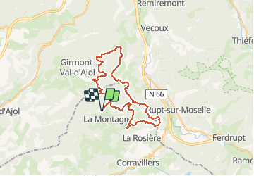
Trail Mountain bike of 29 km to be discovered at Bourgogne-Franche-Comté, Haute-Saône, La Montagne. This trail is proposed by PatriceCocuaud.
Positioning
Country:
France
Region :
Bourgogne-Franche-Comté
Department/Province :
Haute-Saône
Municipality :
La Montagne
Location:
Unknown
Start:(Dec)
Start:(UTM)
319751 ; 5310883 (32T) N.
Comments